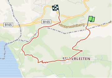
![](/images/other/stat-length.png)
![Excursión A pie Gemeinde Wald im Pinzgau - Zillertal Arena Runde 6 - Photo](https://media.geolcdn.com/t/1900/400/f53a3632-0e52-4fb3-a3c9-cc316b55954a.jpeg&format=pjpeg&maxdim=2)
Zillertal Arena Runde 6
SityTrail - itinéraires balisés pédestres
Tous les sentiers balisés d’Europe GUIDE+
![Longitud](/images/other/stat-length.png)
![Altitud máxima](https://static1.geolcdn.com/siteimages/upload/files/1508320355ic_sort_altitude_max_24dp.png)
![Desnivel positivo](https://static1.geolcdn.com/siteimages/upload/files/1508320355ic_sort_den_pos_24dp.png)
![Km-Effort](/images/other/stat-length.png)
![Altitud mínima](https://static1.geolcdn.com/siteimages/upload/files/1508320355ic_sort_altitude_min_24dp.png)
![Desnivel negativo](https://static1.geolcdn.com/siteimages/upload/files/1508320355ic_sort_den_neg_24dp.png)
![Boucle](https://static1.geolcdn.com/siteimages/upload/files/16400158638029165_repeat_loop_refresh_sync_direction_icon.png)
![A pie](https://static1.geolcdn.com/sitytour/trail-icons/100.png)
1h29
Dificultad : Fácil
![Escanee este código QR para abrir la excursión en la aplicación SityTrail](https://capi.geolives.com/qq0zvz2zws4bq2lad0pu/sitytour/trails/3128013/qr.png?size=200)
Aplicación GPS de excursión GRATIS
A propósito
Ruta A pie de 3,8 km a descubrir en Salzburgo, Bezirk Zell am See, Gemeinde Wald im Pinzgau. Esta ruta ha sido propuesta por SityTrail - itinéraires balisés pédestres.
Descripción
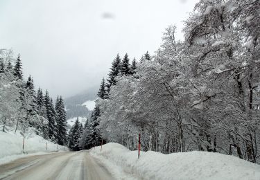
Symbol: Weiße Blechschilder mit grünem oberen Rand mit der Aufschrift "Nature.Fitness Park Nordic Walking". In der Mitte ein schwarzem Punkt mit weißem Richtungspfeil. Rotes Viereck mit weißer Zahl am unteren Rand.
Localización
Comentarios
Excursiones cerca
![Excursión A pie Gemeinde Wald im Pinzgau - Zillertal Arena Runde 5 - Photo](https://media.geolcdn.com/t/375/260/f53a3632-0e52-4fb3-a3c9-cc316b55954a.jpeg&format=jpg&maxdim=2)
![A pie A pie](https://static1.geolcdn.com/sitytour/trail-icons/100.png)
A pie
![](/images/other/stat-length.png)
![](https://static1.geolcdn.com/siteimages/upload/files/16400158638029165_repeat_loop_refresh_sync_direction_icon.png)
![Excursión A pie Krimml - Stauseerunde - Photo](https://media.geolcdn.com/t/375/260/05162670-e071-43c9-9bce-f2b128549ade.jpeg&format=jpg&maxdim=2)
![A pie A pie](https://static1.geolcdn.com/sitytour/trail-icons/100.png)
A pie
![](/images/other/stat-length.png)
![](https://static1.geolcdn.com/siteimages/upload/files/16400158638029165_repeat_loop_refresh_sync_direction_icon.png)
![Excursión A pie Gemeinde Gerlos - Innertal-Runde - Photo](https://media.geolcdn.com/t/375/260/70c476f7-e8d3-4b76-a1cb-9a4ae4ca99a5.jpeg&format=jpg&maxdim=2)
![A pie A pie](https://static1.geolcdn.com/sitytour/trail-icons/100.png)
A pie
![](/images/other/stat-length.png)
![](https://static1.geolcdn.com/siteimages/upload/files/16400158638029165_repeat_loop_refresh_sync_direction_icon.png)
![Excursión A pie Krimml - 2-Seen-Runde - Photo](https://media.geolcdn.com/t/375/260/05162670-e071-43c9-9bce-f2b128549ade.jpeg&format=jpg&maxdim=2)
![A pie A pie](https://static1.geolcdn.com/sitytour/trail-icons/100.png)
A pie
![](/images/other/stat-length.png)
![](https://static1.geolcdn.com/siteimages/upload/files/16400158638029165_repeat_loop_refresh_sync_direction_icon.png)
![Excursión A pie Gemeinde Wald im Pinzgau - Wanderweg 165 - Wald/Königsleiten - Photo](https://media.geolcdn.com/t/375/260/f19ba1db-60c4-4775-8459-e3d3d98a701c.jpeg&format=jpg&maxdim=2)
![A pie A pie](https://static1.geolcdn.com/sitytour/trail-icons/100.png)
A pie
![](/images/other/stat-length.png)
![](https://static1.geolcdn.com/siteimages/upload/files/16400158638029165_repeat_loop_refresh_sync_direction_icon.png)
![Excursión A pie Krimml - Krimmler Wasserfälle Rundwanderweg - Photo](https://media.geolcdn.com/t/375/260/46a143e4-e5b6-40c1-912c-7eedc375993f.jpeg&format=jpg&maxdim=2)
![A pie A pie](https://static1.geolcdn.com/sitytour/trail-icons/100.png)
A pie
![](/images/other/stat-length.png)
![](https://static1.geolcdn.com/siteimages/upload/files/16400158638029165_repeat_loop_refresh_sync_direction_icon.png)
![Excursión Senderismo Krimml - Krimml Waterfalls - Photo](https://media.geolcdn.com/t/375/260/f1f805fd-1700-4ad5-a731-902e6dc9179b.jpg&format=jpg&maxdim=2)
![Senderismo Senderismo](https://static1.geolcdn.com/sitytour/trail-icons/101.png)
Senderismo
![](/images/other/stat-length.png)
![](https://static1.geolcdn.com/siteimages/upload/files/16400158638029165_repeat_loop_refresh_sync_direction_icon.png)
![Excursión A pie Gemeinde Wald im Pinzgau - Wanderweg 734 - Oberpinzgau - Photo](https://media.geolcdn.com/t/375/260/ext.jpg?maxdim=2&url=https%3A%2F%2Fstatic1.geolcdn.com%2Fsiteimages%2Fupload%2Ffiles%2F1545311037marcheuse_200dpi.jpg)
![A pie A pie](https://static1.geolcdn.com/sitytour/trail-icons/100.png)
A pie
![](/images/other/stat-length.png)
![](https://static1.geolcdn.com/siteimages/upload/files/16400158638029165_repeat_loop_refresh_sync_direction_icon.png)
![Excursión A pie Gemeinde Wald im Pinzgau - Wanderweg 731 - Oberpinzgau - Photo](https://media.geolcdn.com/t/375/260/ext.jpg?maxdim=2&url=https%3A%2F%2Fstatic1.geolcdn.com%2Fsiteimages%2Fupload%2Ffiles%2F1545311037marcheuse_200dpi.jpg)
![A pie A pie](https://static1.geolcdn.com/sitytour/trail-icons/100.png)
A pie
![](/images/other/stat-length.png)
![](https://static1.geolcdn.com/siteimages/upload/files/16400158638029165_repeat_loop_refresh_sync_direction_icon.png)